How to Find and Use a Melbourne CBD Map for Stress-Free Exploring
I’ve explored Melbourne with my retired cartographer dad, Chris, who’s spent a lifetime reading—and making—maps. His tips are practical, thoughtful, and full of quiet wisdom. In this guide, I’ll share his insights and walk you through the different kinds of Melbourne city maps available, from digital apps to free printable PDFs. He has even developed a map of his own!
Whether you’re planning a theatre outing, exploring a new café, or finding your way to a hidden gallery, having a Melbourne CBD map in your pocket (or on your phone) can make all the difference.

Why Use a Map in the Melbourne CBD?
Melbourne is one of the easiest cities to navigate—on paper. The grid layout looks straightforward, but once you’re among the trams, crowds, and crosswalks, it can feel like a maze. Add in the city’s network of laneways, new developments, and occasionally hidden signage, and even locals can get turned around.
If you’re using public transport, walking to meet friends, or just exploring the city on your own terms, it helps to carry a Melbourne CBD map with street names and landmarks so you can get your bearings at a glance.
Melbourne Map CBD Guide: From Cartographer Chris
Seniors in Melbourne adventures have led us to many delightful corners of our amazing Capital.
Having been around for a few years now I feel I have an intimate relationship with the City street names and layout. That familiarity however, is often tested when delving into the wealth of interesting, unique, (and sometimes hard to find) places to visit so… I always companion my memory with a map.
If, when walking or using public transport, you decide you need a map then you have a few options and the first choice you are faced with is, printed or digital? Maps are available in many forms and whether you’re a Dora the Explorer or a Phubber affects how you view your location.
I’m more the Dora type and biased towards printed hard-copy maps but I can see pros and cons in either format and invariably use a combination of both.

Digital Melbourne Maps: Handy and Always Up to Date
If you’re using a smartphone, finding a GPS map is free, regularly updated, and packed with useful features—real-time directions, tram stops, restaurant reviews, and walking routes.
Chris says:
I expect that the most popular is Google Maps… Free, always up-to-date and accurate, with a user-friendly interface allowing you to view only the features you select.
But maybe I’m just old-school or it’s a flashback to my boy-scouting days—I like to know my location in the broader, all-embracing sense. On a digital map, if I zoom out, I can’t read the names; if I zoom in, I can’t see where I am in relation to other places!
If you feel the same, you’re not alone.

Printed Melbourne Maps: Your Trusty Pocket Companion
For many of us, there’s no substitute for a printed map you can hold in your hands. It doesn’t run out of battery, and it’s easier to get the “big picture” when you’re sitting in a café or standing on a corner.
Chris says:
A sheet map can overcome digital limitations by showing a larger area that is readable… I invariably use a combination of both.
My suggestion? Research Google Maps at home, locate where you’ll be going and mark it with a bold pen on a free printed map, highlight your route, and then refer to it whenever you desire.
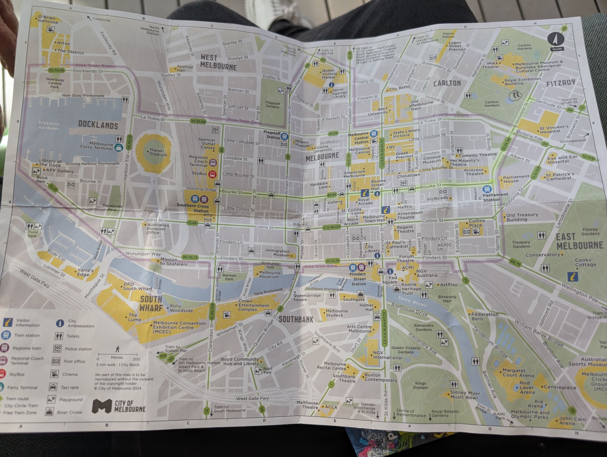
Free Printed Melbourne CBD maps
You can pick up free paper maps from several places around Melbourne:
- Melbourne Visitor Hub at Town Hall
- Melbourne Visitor Booth Bourke Street Mall
- Fitzroy Gardens Visitor Centre
- City Ambassadors (see them in red, situated at various hot spots throughout the city, including at Queens Victoria Market)
- Travellers Aid at Southern Cross Station and Flinders Street Station (especially helpful for anyone needing mobility support)
There is also a printable Melbourne CBD map or two available online (more on that below).
Prefer something more detailed or themed? You can purchase printed maps through bookstores or online, such as the Lonely Planet Pocket Map or street directories.

What’s the Best Melbourne Map to Use?
It depends on your style.
Are you a Dora the Explorer, embracing paper maps with highlighted routes and tea-stained corners? Or a phubber, happy to tap away on a screen while walking and talking? Most people use a mix of both.
Printed maps are great for:
- Getting a full overview of the city
- Planning your day before you head out
- Not relying on your phone
Digital maps are ideal for:
- Finding real-time directions
- Looking up opening hours or reviews
- Discovering new spots on the fly

Free Printable Melbourne CBD Map PDFs
Download and print from home the Official Melbourne Visitor Map, produced by City of Melbourne.
- Download our Seniors in Melbourne CBD map here.
- Find the City of Melbourne CBD map PDF copy here.
- Also, access the City of Melbourne TravelSmart map PDF copy here.
- Then there’s the Melbourne CBD Mobility Map PDF copy here.
- And the Free Tram Zone Melbourne CBD map PDF copy here.
- We also find the National Public Toilet map useful to have on hand!
Digital Melbourne CBD maps
The City of Melbourne offers engaging interactive maps that showcase essential council services, local landmarks, and suburb boundaries. Users can easily navigate to find community facilities and transport options.
- Digital Interactive Melbourne City Maps can be found here.
- Melbourne Access map – the digital/interactive copy – can be viewed online here.
If you know what you want to do in the city, these maps are simple and easy to read, making them perfect if you’re after a simple Melbourne CBD map with only the most useful details.

History Walking Tour Maps
U3A Melbourne City partnered with Walking Maps (part of Victoria Walks) to develop a range of free digital walking maps that highlight some of Melbourne’s historical, cultural, artistic, and natural treasures.
These free maps are perfect for group outings, solo walks, or just browsing online for inspiration. Find them here.

Melbourne Accessibility Map
The digital Melbourne Accessibility Map by the City of Melbourne is an excellent interactive tool for anyone wanting to explore the city with comfort and confidence.
It’s easy to use—you can switch on and off features like disabled parking, accessible toilets, mobility recharging points, public seating, and drinking fountains. There’s also a transport tab that displays train station entrances, tram stops, and bus stops.
Like Google Maps, it works best when zoomed in, but that can make it tricky to get a sense of the bigger picture, especially on a small phone screen.
For those who prefer a printable version, there’s a link just below the map to download the Melbourne Mobility Map as a PDF, which you can print or view on a tablet or computer. It’s not interactive, but it’s clear and practical for pre-planning your route.

Getting Around with Public Transport
If you’re using public transport to explore the Melbourne CBD, a good map pairs perfectly with a Seniors Myki. Holders of a Victorian Seniors Card are eligible for a Seniors Myki, which gives you 50% off all public transport fares, including trams, trains and buses. Read more about that here.
Trams within the Free Tram Zone in the city don’t require a tap-on, but if you’re heading further out—or jumping on a train—it’s worth planning your route in advance. You can use Google Maps or the PTV app (Public Transport Victoria) for real-time transport info, but a printed Melbourne CBD map with tram routes can be a lot easier to read on the go.
Coming Soon: Chris Reviews the Best Melbourne CBD Maps
Chris is currently preparing a follow-up guide, reviewing the best printed and downloadable Melbourne city maps with clarity, accessibility, and practical use in mind.
He’ll share which maps are easiest to read, best for street names, and most helpful for older explorers.

Heading off on your own Melbourne adventures? Join our Facebook Group and share your stories, ask questions and connect with others for further inspiration.
This post contains affiliate links. At no extra cost to you, I may earn a small commission if you click on a link and make a purchase.